Technical Specifications
Product Overview
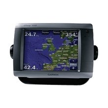
Advanced Touchscreen Marine Navigation
This flagship marine navigator features an intuitive touchscreen interface, allowing for effortless navigation with a simple touch. Equipped with a high-resolution 8.4-inch display, it provides crisp, clear graphics for superior situational awareness. The system supports extensive connectivity, allowing for seamless integration with radar, sonar, weather sensors, and additional multi-function displays via a high-speed marine network.
Display & Interface
- Screen Size
- 8.4 inch
- Interface Type
- Touchscreen
Mapping & Cartography
- Preloaded Cartography
- BlueChart g2U.S. CoastAlaskaHawaiiBahamas
- Worldwide Basemap
- Worldwide with high-quality satellite imagery
Connectivity & Expansion
Network Compatibility
- Radar
- Sonar
- XM Satellite Weather
- XM Satellite Radio
- Multi-function Displays (MFDs)
- Remote Sensors
- Expansion Slots
- SD Card Slot
- Video Input/Output
- Yes
Included Accessories
Included Components
- GPS Receiver
- Pole Mount Adapter