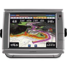
Marine GPS Chartplotter with Touchscreen
This marine GPS chartplotter features a high-performance touchscreen for clear visibility. It supports detailed cartography and integrates with autopilot, radar, and sonar systems.
Technical Specifications
Overview
Professional Marine Navigation
This high-performance touchscreen GPS chartplotter represents the next evolution in marine navigation technology. Designed for both recreational and professional use, it offers a robust, sunlight-readable display and intuitive interface for seamless route planning and waypoint management. Built to withstand harsh marine environments, this unit provides reliable performance and comprehensive situational awareness.
Display & Interface
- Interface Type
- Touchscreen
- Visibility Features
- Sunlight-readable
Navigation & Cartography
Supported Cartography
- BlueChart g2
- BlueChart g2 Vision
Navigation Capabilities
Route PlanningWaypoint ManagementData Monitoring
System Integration
Connectivity
- Network connectivity
- Autopilot integration
- Radar compatibility
- Sonar capabilities
Live Navigation Data
0.5 kn
Speed
3.54 nm
Distance
315 deg
Heading
Durability
- Environmental Suitability
- Designed for harsh marine environments