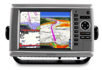
Marine GPS Chartplotter with Sunlight-Readable Display
This marine GPS chartplotter features a sunlight-readable display for clear visibility. It supports radar, sonar, and other marine sensors for comprehensive situational awareness.
Technical Specifications
Overview
High-Performance Marine Navigation
This high-performance GPS chartplotter is designed for professional marine navigation, featuring a large, sunlight-readable display for optimal visibility in all lighting conditions. Equipped with high-speed graphical processors and advanced motion technology, it delivers ultra-smooth map panning, zooming, and seamless graphical updates. It serves as a comprehensive solution for situational awareness by integrating radar, sonar, and other marine sensors.
Performance Metrics
Key Performance Indicators
168
Display Index
62 MHz
Processing Speed
8.7 Hz
Refresh Rate
1.3
System Version
Technical Features
System Integration
- Radar Support
- Sonar Integration
- Marine Sensor Network
- Data Sharing Capabilities
- Display Technology
- Sunlight-ReadableHigh-Speed GraphicsUltra-Smooth PanningSeamless Updating
Charting Capabilities
Charting Features
| Feature | Capability |
|---|---|
| Coastal Coverage | Detailed |
| Visuals | High-Resolution Satellite |
| Perspective | 3D View |