Data Acquisition and Survey System
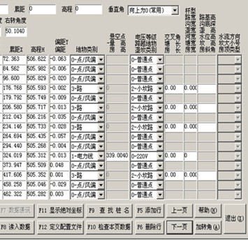
This is software designed for data collection and surveying. The interface allows users to input and manage data points, coordinates (X, Y), elevation, and classifications of terrain features.
Technical Specifications
Product Overview
Professional Data Acquisition and Survey System
This comprehensive software solution is designed for professional surveying and geographic data collection, specifically optimized for line research and terrain analysis. It features a robust interface for managing complex data points, including coordinates, elevations, and terrain classifications. The system is ideal for infrastructure planning, allowing users to track overhead obstructions and electrical voltage levels with high precision.
Core Functionality
- Data Management Capabilities
- Data Import/ExportCoordinate DisplayData ValidationAngle AdjustmentsAbsolute Coordinate Search
Survey Parameters
Tracked Parameters
- X, Y Coordinates
- Elevation (High-level)
- Vertical Angles
- Distance Adjustments
- Right Turn Angles
- Roadbed Width and Depth
Infrastructure & Terrain
Terrain & Feature Classification
- Overhead Obstructions
- Electrical Voltage Levels (e.g., 220V)
- Terrain Feature Classification
- River Water Levels and Flow Direction
- Building Heights and Roof Types
Software Interface
Interface Features
- Real-time Data Communication
- Configuration File Definition
- Data Page Inspection
- Stake Name Search
- Wind Deviation Points
Technical Metrics
Sample Data Processing
| Distance | Elevation | Point Type |
|---|---|---|
| 72.363 | 506.622 | Standard Point |
| 84.562 | 505.982 | Wind Deviation |
| 176.768 | 505.593 | Road/Path |