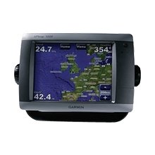
Marine GPS Receiver with Color Display
This marine GPS receiver is designed for navigation and chartplotting. It features a high-resolution color display, advanced mapping capabilities, and supports various marine sensors and accessories.
Technical Specifications
Product Overview
Advanced Touchscreen Marine Navigation
This flagship marine navigator features an intuitive touchscreen interface, allowing for effortless navigation with a simple touch. Equipped with a high-resolution 8.4-inch display, it provides crisp, clear graphics for superior situational awareness. The system supports extensive connectivity, allowing for seamless integration with radar, sonar, weather sensors, and additional multi-function displays via a high-speed marine network.
Display & Interface
- Screen Size
- 8.4 inch
- Interface Type
- Touchscreen
Mapping & Cartography
- Preloaded Cartography
- BlueChart g2U.S. CoastAlaskaHawaiiBahamas
- Worldwide Basemap
- Worldwide with high-quality satellite imagery
Connectivity & Expansion
Network Compatibility
- Radar
- Sonar
- XM Satellite Weather
- XM Satellite Radio
- Multi-function Displays (MFDs)
- Remote Sensors
- Expansion Slots
- SD Card Slot
- Video Input/Output
- Yes
Included Accessories
Included Components
- GPS Receiver
- Pole Mount Adapter