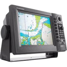
Marine GPS Chartplotter with Sensor
This marine GPS chartplotter is designed for navigation with a vibrant color LCD display. The integrated GPS receiver provides accurate positioning, route planning, and waypoint management.
Technical Specifications
Overview
Integrated Navigation System
This advanced marine navigation system combines radar, GPS/WAAS chart plotting, fish finding, and weather facsimile capabilities into a unified network. Designed for high reliability and expandability, it supports seamless data sharing across multiple display units via Ethernet. The system is optimized for both single and multi-display installations, ensuring stress-free navigation and robust performance in marine environments.
Key Features
- Core Capabilities
- GPS/WAAS Chart PlotterRadar IntegrationFish FinderNetwork Weather FacsimileEthernet Networking
Technical Specifications
- Display Technology
- AR-coated, high-brightness LCD for improved sunlight viewability
- Chart Compatibility
- C-Map NT MAX
- Storage Media
- SD Card
- Installation Type
- Plug n Play with wizard style set-up
System Compatibility
Network Features
- Ethernet-based network architecture
- High-speed data transfer
- Multi-display installation support
- Cross-component control capability